Great blue herons recover in Chesapeake Bay
October 15, 2026By: Chance Hines
9/29/2026
A new analysis of Whimbrel migration brings together tracking data from around the world to identify global threats to whimbrel. The 2.6 million locations from 251 Whimbrel that researchers used to identify broad patterns in migration, movements, timing, and gaps in our understanding of this wide-ranging shorebird, include many tagged by CCB.

Chance Hines releases a tagged whimbrel on Virginia’s Eastern shore in 2022. Photo by Bryan Watts.
CCB’s contribution to understanding whimbrel ecology through tracking began two decades ago, when CCB became the first group to track whimbrels with satellite transmitters. Prior to that time, satellite transmitters were too heavy for most birds and were best suited to larger-bodied animals. Whimbrel, one of the largest shorebirds in North America, were an early target for tracking studies as advances in tracking technology allowed lower package weights. In 2008, CCB researchers led the first project to capture and attach transmitters to whimbrels on Virginia’s Eastern Shore allowing them to follow its movements for the first time.
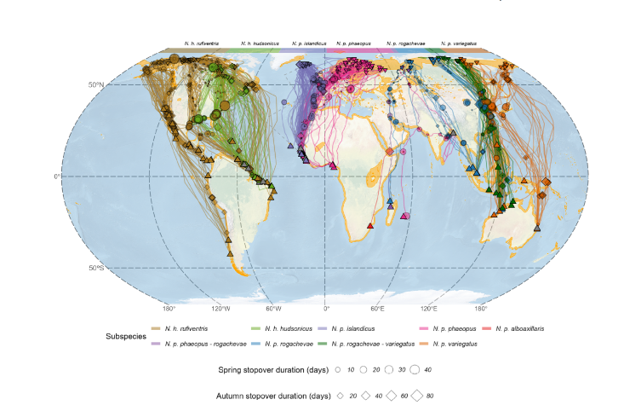
Tracks of whimbrel subspecies tagged throughout the world. Figure from Carneiro et al. 2026.
Tracks from those birds revealed a lot about migration routes that had been difficult to understand through field observations alone. One of the first tagged birds that left Virginia in late May traveled more than 5,000 kilometers northwest toward the Mackenzie River and eventually the breeding grounds in Alaska. Its route not only included a long non-stop flight but also suggested that Whimbrel from western breeding populations could pass through the Atlantic coast during spring migration, bringing birds from populations previously thought to have disjunct migration routes into contact.
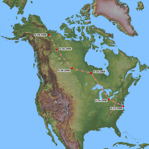
Tracks of one of the first whimbrel tagged. At the time, the non-stop flight from the Eastern Shore to the MacKenzie Delta was the longest documented flight by a whimbrel. After two decades of tracking we now know that these types of flights are far from unusual. Data from CCB.
Tracking technology has advanced dramatically since 2008. Satellite transmitters have continued to get lighter with more efficient solar cells for charging transmitters and more capable of storing larger amounts of data. These advancements have allowed researchers to follow birds for longer periods and collect more detailed information about their movements. These advancements have allowed CCB to continue contributing to the expanding body of Whimbrel research, helping document population-specific migration routes, important stopover areas, and where and when whimbrels are exposed to the greatest threats.
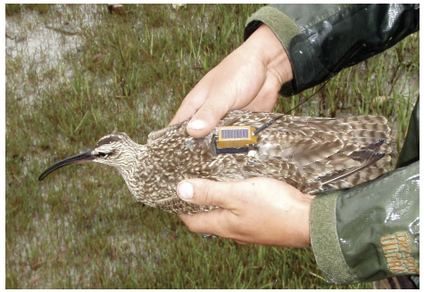
One of the first whimbrels tagged with satellite transmitter. This bird was captured by CCB and TNC staff in 2008 on Virginia’s Eastern Shore. The transmitter used for this project collected a handful of locations every day and uploaded them to satellites. Photo by Fletcher Smith.
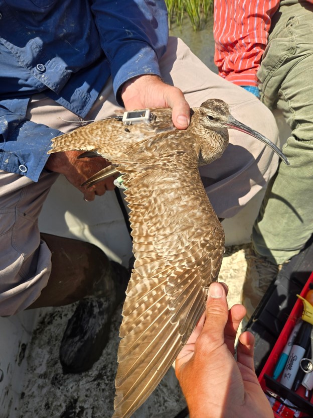
Bryan Watts (CCB) and Mario Balitbit (TNC) inspecting wing feathers of the most recently tagged whimbrel during the 2026 autumn migration on Virginia’s Eastern Shore. The newer tags collect thousands of locations per day, upload data via cellular phone towers, and can be reprogrammed remotely. Photo by Mario Balitbit.
For CCB, the new global analysis represents another step in a long history of using new technology to understand where Whimbrel go and how the places they depend on are connected. What began with the first Whimbrels tagged on Virginia’s Eastern Shore has grown into a global network of tracking studies. CCB’s continued contributions to that effort are helping fill the picture of how Whimbrel move across the hemisphere and which places are most important for conservation.