Camellia in Hampton & York County
Camellia Visits Hopewell, VA area
August 9, 2010Camellia in Hampton & York County
August 15, 2010
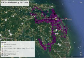
Since our last map at 6am Aug 9 when Camellia was in Surry County, VA at Guilford Heights on the James River, he has explored some highly populated (by humans) new territory. He spent the entire day Aug 9 along the shore of the James River near Guilford Heights. On the morning of Aug 10 he crossed the James River back to Tettington and stayed there over night. At 11am Aug 11 he flew first north along the James a few miles then did a U-turn to the mouth of the Chickahominy River and turned eastward flying north of Williamsburg to the York River. Here he turned southeast to the city of Hampton and the Phoebus area at 4pm where he again did a U-turn flying north along the east side of Interstate 64. At the landfill just south of J. Clyde Morris Blvd (U.S. Route 17) he turned east and flew to the Big Bethel Reservoir on the border of Hampton and York County. Camellia spent the night at Big Bethel Recreation Area in Hampton. He left there at 6am Aug 12 and flew west to two small ponds in the neighborhood of Westview Green north of the landfill and just east of I-64. He left the ponds after 8am flying north to the intersection of I-64 and U.S. Route 17 in Newport News and at 9am turned eastward . This map ends at 11am Aug 12 and Camellia was flying over York County and the neighborhood of Roberts Trace just south of Victory Blvd and about 1 mile from Poquoson. He was headed eastward. Next map will tell us where he was going.


2 Comments
Cool-I hope he hangs around in York County.
Anxiously awaiting the next map to see where our boy has traveled.