Grace – Loop – West Neck to West Neck 2/13/16

Grace Flies to Virginia Beach Feb 7 2016
February 8, 2016Grace at NC Catfish Farm 2/21/2016
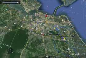
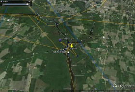
February 22, 2016Grace has made a long loop from the junction of West Neck Creek and the North Landing River to Isle of Wight County and back to West Neck. Grace began her journey at West Neck Creek Feb 8 (YELLOW arrow) leaving the morning of Feb 9 flying east to Back Bay, turning north and flying to Cavalier Park on Linkhorn Bay (DARK BLUE pointer), then west flying across Norfolk Botanical Garden and Lake Whitehurst between 2:00 and 3:00pm (Pink pointer). She then turned south and spent the night on the A&C Canal in Chesapeake. Early on the morning of Feb 10 she flew east into Virginia Beach where she reversed course and flew west to Portsmouth (GREEN pointer) then spent the night along the James River in Isle of Wight County. Grace then flew to Smithfield, VA (LIGHT BLUE pointer) by 1:00pm Feb 11, reversed course again flying east to Great Bridge in Chesapeake (ORANGE pointer) then back to West Neck Creek and the North Landing River to roost over night. As of this satellite map Grace is spending the night along the North Landing River just south of West Neck Creek (WHITE arrow Feb 13 at 8:00pm). The blue line on the map is an old flight line of Camellia that I can’t figure out how to remove. Click on maps to enlarge.


3 Comments
Thanks Reese. I hope she settles close to home so I can go out and see her.
Ms.Grace is not staying still long..don’t want your picture taken “big girl”? Safe travels beautiful..Thank you Reese.. I kinda like Cam’s blue line..now that I know what it is..ha
Wonderful news. Maybe someone will spot her. Stay safe and well Grace, and thanks Reese!