Camellia Returns to Charity Neck May 26
Azalea Also At Red Wing Golf Course
May 26, 2011Azalea Remains At Red Wing Golf Course May 27
May 28, 2011

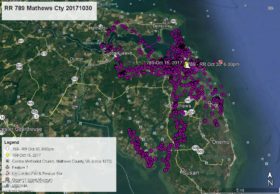
After spending four nights May 23, 24, 25, 26 at Red Wing Golf Course, Camellia returned to the farm field at Charity Neck Rd and Gum Bridge Rd behind Charity United Methodist Church about 7:00pm May 26. The afternoon of May 25 he made a brief flight over the Virginia Beach Municipal Center. As of this satellite tracking map at 4:00pm Friday May 27 he was still at the Charity Neck farm field – white data point. Click on maps to enlarge.


1 Comment
Thanks, Reese. Their paths are always interesting and their nearness to each other intriguing.