Blog Site Address
August 12, 2009
Flight of Hope
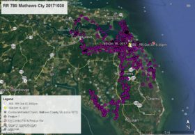
August 14, 2009 Azalea has wandered even farther from Norfolk Botanical Garden. The lowest center data point is over the Haygood area near Independence Blvd in Virginia Beach at 3:00pm on August 5. The most eastern point (far right) is over Bay Colony and Broad Bay in Virginia Beach on August 8 at 1:00pm. The far upper left data point is over Hewitt Farms/Belaire neighborhood in Norfolk on August 11 at 4:00pm. You will notice that all three of these times are during the afternoon when she is more likely to be soaring. Other than at those times Azalea has been staying close to NBG spending most of her time either in the nest tree, camera tree or at “the dump”. Broad Bay is about 7 or 8 air miles from NBG and that is encouraging to see her that far from NBG.

14 Comments
She is getting around well-and seems that she has been spotted by some of the eagle watchers in their nieghborhoods !!!!
Good girl AZ.
Hi Rose – Question for you!! Do you know who spotted Azalea in their neighborhood and when? Would like to tie that info in to the satellite data.
Hello, Also does she have a parent with her or is she alone? Has anyone spotted her “fishing” when she is over water?
There are some cool pics on the VDGIF site of the adult male passing a fish to Azalea in air.
This is awesome being able to see her expand her territory and exactly where she goes. It’s been very nice seeing her stay around the garden as long as she has too but I’m really looking forward to seeing where this little lady travels.
Shelly,Va. Beach What wonderful photo’s of dad exchanging fish with Azalea. Dad needs to be careful she’s a big girl, if she grabs him instead of fish …that would be awful. He looks exhausted sitting in the tree after the exchange!
I notice that she is still hanging around these parts and I’m wondering will this be a problem? I don’t see her leaving anytime soon. (It’s wonderful to see her, but…) Glad to see a parent is always around for her. Nice captures in the air on her talon “application” studies. 😉
How long will the web cam be up?
Looks like she goes wandering every 3 days. Wonder if she’ll be out exploring tomorrow?
Reese, according to map, it DOES look like she has passed over my house heading over to Lake Smith right by Northampton (Amy’s sighting??). I was kidding on the forum the other day about looking up for her….I think I’ll have to keep a look-out! Thanks for the update.
Mr. Lukei, I have a question about eagle behavior. When the eaglets were small dad would bring food to the nest give it to mom to feed the babies, when they got older twice I saw him land with food , mom would “puff” her feathers lower her head, stare and do a long “squawk” She wanted him to leave. Why? Would she have attacked him?
Azalea spends a great deal of time in either the nest tree or the nearby camera tree. Do eaglets seek a surrogate sibling when the others have left – has AZ substituted the camera as a “companion”?
I’m interested in seeing if I can observe Virgil Cain when/if she flies over Vermont. Can her satellite location be linked to GoogleEarth to get a continuous update on her location?
Thanks
Bob
White River Jct
Bob – The best way to follow Virgil Caine is to keep track of her flight on wildlifetracking.org like you are likely doing. When a new data point is posted, go to a map program like MapQuest, put in the nearest town, then zoom in to see a closer view of her location. Hope this helps you. We do not get daily satellite transmission reports.