Azalea Returns to Marsh in Hampton
Camellia Wandering About Virginia Beach Again!
October 10, 2011NBG Camera Turned On Today Oct 12
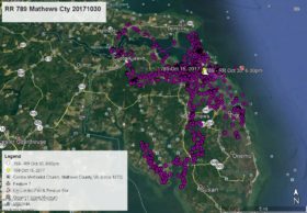
October 12, 2011On our last satellite map Azalea was on the western branch of the Lynnhaven River in Thalia (5:00pm Oct 6 Yellow arrow). She spent the night on Thalia Point (Blue pointer 1:00am Oct 7). She left this area about 9:00am Oct 7 and flew to the eastern branch of the Lafayette River in Norfolk in the Lakewood neighborhood and spent two nights in Cromwell Farms (Green pointer 1:00am Oct 8 and Purple pointer 1:00am Oct 9). On Oct 8 she made an afternoon flight over to Craney Island in Portsmouth and then returned to Cromwell Farms. The morning of Oct 9 she flew north first to Mason Creek off Granby St in Norfolk, then across Norfolk Harbor back to the marsh at the intersection of I-64 and I-664 in Hampton where she spent the night and is as of 7:00am this morning Oct 10 – White arrow. Click maps to enlarge.


4 Comments
i wish i had known this morning that she was there. i’ll swing through on my way home from work today and see what I can see…
I swung through this neighborhood after work yesterday and the man who lives there had seen her a few months ago and pointed out the tree she had been in. There’s good visibility to the tree, but she was no longer there…
Ok – I was driving on 64 yesterday around noon and near that marsh and saw what I thought was a juvie flying ! It must have been Azalea!!!
WooHoo!
Nice to see Azalea in the neighborhood – coming home for “Mom” Norfolk’s dedication at NBG!
Thanks for all the updates Reese