KE Remains Near Hanover, VA Dec 5 2013
Camellia at Stumpy Lake Dec 4 2013
December 7, 2013Tracked eagles continue to blaze trail for conservation
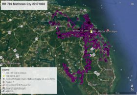
December 12, 2013KE (juvenile bald eagle from Saw Pen Point in Virginia Beach in 2012) just does not seem to have any desire to travel far from Hanover, VA. In 2012 she spent most of Nov and Dec on the Pamunkey River east of Hanover and has so far done the same thing in 2013. This map covers Nov 25 to Dec 5 and KE’s flight is the GREEN line. The ORANGE lines are her previous travels in this area. Click on maps to enlarge.


7 Comments
Thanks Reese – would be nice if KE paid us a visit but it doesn’t look like she has any interest in heading south yet.
Its great to see where KE is. I was out on Dec 1 checking east of Fredericksburg, -King George Landfill and east of 301, in case any of our young ones were in sight (KE and NX).
Pending, I’ll go this weekend. We gotta make sure she knows she is loved! Normans Bridge Road and the Pamunkey River — a new landscape! Thanks!
That’s interesting that she spent Nov and Dec 2012 and the same time frame this year at the same area.
I don’t think it’s genetic, I have been wondering if KE has NX-itis!
Very interesting maps, I wish I lived closer.
Thanks Reese
Good luck Magin!!!
Good to finally hear from KE.Guess she has found a place she likes ..doesn’t seem to have an interest in comming home..but you never know with eagle..stay safe lil one…Thanks Reese
Reese, KE is a few miles from my house. We put the kayak in where she is right now (which is actually Rt 301, not 2). Let me know if you want me to check on her. Barb
Response – The maps is as of Dec 5 so I expect KE has moved on. I will get a new map next week. The VA State map shows the highweay as Rt 301 and Rt 2. Google maps placed the 2 over the 301. Nothing I can do about that. Nice to know she is near one of our avid viewers. She has been shy and no one has yet to get her photo since leaving Va Beach in 2012.
I left town rather late, having to include shopping with more shopping on the way south.
No sign of eagles in sky or along trees as I looked around 301 (and boat ramp), Norman’s Bridge Road, Hanover Quarter, a bit to the south along River Rd, and a bit north up to Dawn Rd (30) again. Had I arrived earlier in the day, I would have called Barb to help me find possible better access points! Beautiful country, but pretty waterlogged!