Camellia Off Princess Anne Rd in Va Beach 10/30
Camellia at Princess Anne Country Club in Va Beach 10/27
October 28, 2013KE Returns to Pamunkey River/Hanover County Oct 31 2013
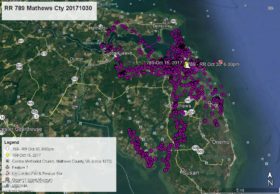
November 4, 2013Well, after exploring three golf courses, Camellia has flown to a heavily wooded and swampy area between Princess Anne Rd and the North Landing River, and north of N. Stowe Rd in Virginia Beach. First time he has visited in this location. Here are his data points – YELLOW arrow Oct 27 at 6:00pm, PINK pointer Oct 28 at 2:00pm, GREEN pointer Oct 29 at 1:00am, BLUE pointer Oct 29 at 11:00am, ORANGE pointer Oct 30 at 1:00am, PURPLE pointer Oct 30 at 1:00pm, and as of this map WHITE arrow Oct 30 at 6:00pm.


3 Comments
BackBay area..maybe a branch of Westneck Creek..looks like
Response – West Neck Creek is a few miles further north.
Looks like he’d be hard to find there. Can’t wait for the next map to see where he shows up! Thanks, Reese.
Hope to see you this week, meet you at Fentress???
Thanks Reese!