Azalea in Grassfield Section – Chesapeake Jan 3, 2013
Camellia at Bow Creek Golf Course New Years Eve
January 2, 2013Camellia at Cavalier Golf Course Jan 3, 2013
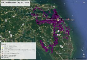
January 3, 2013Azalea has been flying back and forth across US Route 17 between the Great Dismal Swamp NWR and the Grassfield section of Chesapeake. She appears to be in flight heading northeast over New Mill Creek as of this satellite map. Here are her data points – YELLOW arrow Dec 31 at 1:00am, PINK pointer Jan 1 at 1:00am (behind Grassfield High School), GREEN pointer Jan 2 at 1:00am, BLUE pointer Jan 3 at 1:00am, and as of this map WHITE arrow Jan 3 at 9:00am.


4 Comments
AZ, be out looking for you tomorrow, now stay in that area! Please.
Another exciting map day, thanks Reese!
Thank you Reese for keeping us up todate. So glad Camellia’s tracking device is working again. Glad our NBG ‘eaglets’ are staying around the area.
Glad to have both “our” birds in sight.
In the Deep Creek/Great Bridge area know it well.I will have my eye’s to the sky looking for you beautiful…