Camellia Still Near Benefit Rd, Chesapeake 11/9
Azalea Also in Chesapeake 11/6
November 6, 2012Azalea in Sandbridge Area of Virginia Beach
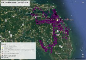
November 10, 2012Camellia starts and ends in the same place on this map. He was last near Benefit Rd and Curling Ct – YELLOW arrow Nov 6 at 3:00pm. He has remained in the same general location the past 4 days, making one flight over the Chesapeake Regional Airport (private) BLUE pointer Nov 8 at Noon. Here are his other data points – PINK pointer Nov 7 at 1:00am, GREEN pointer Nov 8 at 8:00am, ORANGE pointer Nov 9 at 1:00am, and as of this map WHITE arrow Nov 9 at 5:00pm. Camellia appears to be finding fish in a drainage ditch that drains out of the Great Dismal Swamp NWR. I am off to Haines, Alaska tomorrow to attend the Alaska Bald Eagle Festival – http://baldeagles.org/festival. Back on Nov 20.


1 Comment
some of the water flooded and some drained out down here after the storm..maybe trapping fish…Cam is always looking for an easy meal..like flooded fields at Back Bay..Ha !