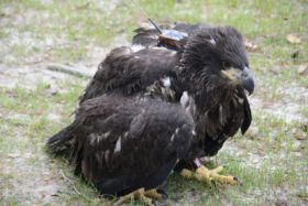
Azalea on Hoffler Creek in Portsmouth, VA
Camellia Remains in Great Neck 3/24
March 26, 2012Photos – Male & Female #4 March 25
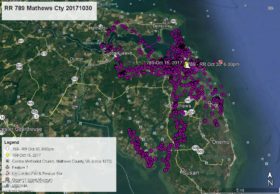
March 26, 2012Azalea began this map period in the River Pines neighborhood in Great Bridge, Chesapeake (YELLOW arrow Mar 22 at 1:00am). The morning of Mar 22 she flew north to Stearns Creek on the Chesapeake/Portsmouth line and spent the night on the Chesapeake side in the Point Elizabeth neighborhood (PINK pointer Mar 23 at 1:00am). On the 23rd she spent most of the morning near the mouth of Stearns Creek where it empties into the Elizabeth River. In the afternoon she flew east over downtown Portsmouth, then northwest to Hoffler Creek at Burbage Point where the creek enters the James River, then south to spend the night on the Portsmouth side in the Long Point neighborhood (GREEN pointer Mar 24 at 1:00am). Mar 24 was spent on Hoffler Creek and as of this satellite map Azalea is on the Portsmouth side of Hoffler Creek – WHITE arrow Mar 24 at 6:00pm.


