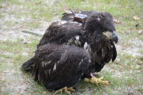
Camellia Still in Norfolk 6/29
Azalea still Eating Catfish
June 26, 2011Azalea Still in Plymouth, NC 6/29
June 29, 2011

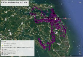
Camellia did make two afternoon flights but is still just off the Eastern Branch of the Elizabeth River. On June 26 he flew to Trashmore II, the Virginia Beach landfill off Kempsville Rd. On June 28 he made another flight a bit further south into Chesapeake to Kemp Woods South, but returned to the Elizabeth River. As of this map at 7:00pm June 29 (just 1 1/2 hours ago) he was on a small creek along I-64 in the Norfolk neighborhood of Pleasant Point – white arrow. Click on maps to enlarge.


3 Comments
Reese, I always find these tracking maps fascinating. Question: How often do you upload data from their transmitters? Is it done automatically or do you physically have to upload it? Thanks for the great work you and CCB do to keep us informed and involved.
Response. The satellite transmitter collects the GPS data for three days or more and transmits it to the French company Argos. I have to go up on their site and collect the raw data, then parse (translate) the data into a Google program, then analyze the data and write the blog. Takes up to two hours. – Reese
Camellia is an urban eagle. So different than Azalea. Thanks Reese
Reese….curious if he seems to be active early or later in the day or does it not matter. I’ve been up and down Military Highway and the interstate all week keeping an eye out but haven’t seen anything resembling as Eagle in those areas.
Response – The only regular pattern is if Camellia is going to leave an area he does so by 10:00am. Most of the time leaves his overnight roost tree by 6:00am this time of year. Both of the ventures away from the Elizabeth River on 6/26 and 6/28 were done in the afternoon – warm air rises requiring less energy. But no regular schedule while in an area for several days like doing now.