Camellia at Red Wing Lake/Atlantic Shores April 30
Camellia Returns To Pocaty River Apr 27
April 28, 2014Camellia at Nanney’s Creek – Va Beach May 2
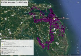
May 3, 2014Camellia has been wandering around eastern Virginia Beach for the past three days. Follow the RED LINE – YELLOW arrow (Pocaty River), PINK (Nanney’s Creek), GREEN (Charity Neck), BLUE (Pungo), ORANGE (LagoMar), PURPLE (Lake Tecumseh), YELLOW (Corporate Landing), and as of this satellite map WHITE arrow at 4pm April 30 (Red Wing Lake near Atlantic Shores). Click on maps to enlarge.


2 Comments
So glad the transmitter is working.. not a lot of sunshine lately. find a nice tree overlooking a creek and dry out Cam..Thanks Reese..Is a transmitter going to be put on an eaglet this year?
Response – Not sure Pat. Two nests we had our eyes on failed this year, and another eagle pair moved to new nest.
Cammy sure is racking up frequent flyer miles, revisiting many favorite areas! Let the sun shine!
Thanks Reese, an exciting Map Day.