Camellia Travels to Hatton Point in Portsmouth 2/4
KE at Swift Creek Reservoir Jan 30 2014
February 4, 2014KE Has been Exploring Feb 6 2014
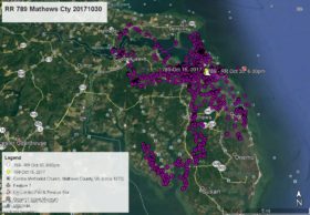
February 8, 2014Surprise! The satellite transmitter that Camellia is wearing sent enough data to know that he has flown to Hatton Point in Portsmouth on the Western Branch of the Elizabeth River and the mouth of Carney Creek. There were gaps in the data so the GREEN line may not be the exact route he took to get to Portsmouth. Data points are YELLOW arrow Feb 1 at 4:00pm, PINK pointer Feb 2 at 1:00am, GREEN pointer Feb 2 at 2:00pm, BLUE pointer Feb 3 at 1:00am, ORANGE pointer Feb 3 at 2:00pm, and as of this satellite map WHITE arrow Feb 4 at 7:00am.


2 Comments
Glad you’re around Cammy, fly safe and let the sun shine!
Thanks for the update Reese, glad he is transmitting at all
I know where you are Cam..Hubbie’s grandmother lived at Hatton Point.Hope the water isn’t frozen and you find fish (or frogs..Ha) Let the sunshine indeed Ms Beverly..Thanks Reese