KE – I Am Still On The Pamunkey River Nov 14 2013
Camellia at Sussex County Landfill Nov 15 2013
November 15, 2013Camellia Remains At Sussex County Landfill Nov 18
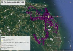
November 18, 2013KE has yet to return to Virginia Beach where she was born and where she left on July 29, 2012. All the lines on these maps show that she has been on the Pamunkey River (note that two state issued maps spell the river Pumunkey and Pamunkey – The Indian Reservation is spelled Pamunkey) much of her time. Note that Route 2 is also US Route 301 going through Hanover, VA. On the close-up map the BLUE LINE is the boundry between Hanover (west) and King William (east) counties (and the river). The ORANGE lines show KE’s flight paths prior to Nov 6 and the GREEN lines since Nov 6. The flight order of the color data points are YELLOW arrow (Nov 7 at 4pm), PINK, GREEN, BLUE, PURPLE, ORANGE, and YELLOW pointers, and as of this map WHITE arrow (Nov 14 at 4pm). Click on maps to enlarge.


2 Comments
KE you left home and never looked back..guess this area is home to you now..Thanks for the update Reese
Pat, don’t despair! She will get home one of these months. She is quite the traveler, tho.
I can’t believe how specific the data is now, with the time and date by the pin as well as the colored current activity. Reese, this is terrific! Do we not get the data the same way for Camellia?
KE, take care!