Camellia Transmitter Back In Service Nov 6 2013
KE Returns to Pamunkey River/Hanover County Oct 31 2013
November 4, 2013Camellia – Curling Acres – Chesapeake, VA 11/08/2013
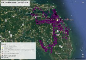
November 9, 2013Have you noticed that there was no posting for Camellia for a few days? That is because his satellite transmitter solar battery reached a very low level and the transmitter sent out no data between Oct 31 at 1:00am and Nov 5 at 2:00pm. Through other data we do know that during part of that time Camellia was near Oceana Naval Air Station in Virginia Beach. As of this map at 10am today he is south of the Chesapeake Regional Airport, east of US Route 17 and north of Cornland Rd in Chesapeake. Here are his data points – YELLOW arrow Oct 30 at 6:00pm, PINK pointer Oct 31 at 1:00am, GREEN pointer Nov 5 at 2:00pm, PURPLE pointer Nov 6 at 1:00am, and as of this map WHITE arrow Nov 6 at 10:00am.


6 Comments
Yes, I noticed!! Kept checking every day for “map day”! Whew, glad he finally decided to send a signal. Thanks, Reese!
Hope he’s finding plenty to eat in those field ditches.
I noticed, too! Didn’t know whether you were out of town or what, but I’m so happy to “see” him again!
Yep..I noticed..hopeing for the best but was ready for the “stopped working” news, Thought for a long time Az’s transmitter would start up again..realy miss her.hope she is safe,healthy an has found a mate.Happy for a little more time with Cam.Thanks Reese
So happy he is sending data again. Let the sun shine for you Cammy! Be seeing you.
Thanks Reese for another exciting Map Day!
Glad he is transmitting again, but do wish he would stay away from those airports. Go back to the golf courses, Cammie!