Camellia Visiting Mill Landing Road Again
Azalea Stll at Catfish Farm in NC
June 12, 2012Azalea – No Change in Location
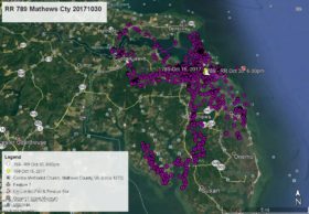
June 15, 2012Camellia is still in “the country”. He has just moved a bit further south in Virginia Beach to another farm field that he has visited before off Mill Landing Rd. The creek you see is Nanney’s Creek (some maps show as Nawney but that is not we locals call it). The farm ditches flow into Nanney’s Creek and then into Back Bay. Here are Camellia’s data point – YELLOW arrow June 11 at 1:00am, PINK pointer June 12 at 1:00am, GREEN pointer June 13 at 1:00am, PURPLE pointer June 14 at 1:00am, and as of this satellite map WHITE arrow June 14 at 10:00am. Click maps to enlarge.


1 Comment
It’s such a treat to see where Camellia and Azalea are. Thank you, Reese.