Azalea Returns to North Carolina 5/6
Camellia Near Military Circle – Norfolk
May 6, 2012Camellia At TPC Golf Course In Va Beach 5/9
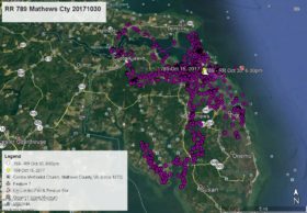
May 10, 2012Azalea appeared to be on the move southward on our last map and she was (YELLOW arrow May 3 at 3:00pm). She continued south to the Princess Anne Wildlife Management Area and stayed overnight (PINK pointer May 4 at 1:00am). From there she flew just over the border into North Carolina and stayed the night on Knotts Island (GREEN pointer May 5 at 1:00am). She then flew west across Mackay Island National Wildlife Refuge (http://www.fws.gov/mackayisland/) to Sandy Point right on the VA/NC line (PURPLE pointer May 6 at 1:00am). After spending the morning at Sandy Point she flew across the North Landing River (sound familiar?? – Honey Bee Golf Course is a few miles north) to Gibbs Woods in Currituck County, NC and as of this map is just east of Whitehurst Rd – WHITE arrow May 6 at 6:00pm.


3 Comments
The up-dates make me smile.
I was so hoping Azalea would have stayed at Honey Bee so I could have seen her while I was in town. Oh well, maybe I can find Camellia. Just as long as they are safe and flying free is all I really need to hear!!!
Reese, loved your lecture the other morning at the symposium. Wonderful recap of the Norfolk nest.
Hmmm, I wonder if she’s headed to the catfish farm?