Camellia In West Neck Creek Natural Area 4/21
Camellia Near Virginia Wesleyan College
April 18, 2012Azalea Returns to Honey Bee 4/21
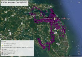
April 22, 2012Camellia began this satellite map period at Virginia Wesleyan College (YELLOW arrow Apr 18 at 10:00am) and remained all day at the campus and at Norfolk Academy (a private school) next door (PINK arrow Apr 19 at 1:00am). On the afternoon of the 19th he flew south about 4 miles to an old haunt Carolanne Farms on the Elizabeth River (GREEN pointer Apr 20 at 1:00am). After flying about the Kempsville area of Va Beach he flew further south to the Va Beach Landfill known as Trashmore II (PURPLE pointer Apr 21 at 1:00am). From there Camellia flew east to the West Neck Creek Natural Area between Holland Rd and London Bridge Rd which is where he is as of this map just behind the Holland Pines neighborhood at a small pond – WHITE arrow Apr 21 at 4:00pm.


2 Comments
Hmm, maybe he’s going to make his way down to HB too!?! Thanks as always for the updates, Reese.
Seems like our Cam is loving life! Be safe , sweet boy!