Camellia Spends 3 Days on West Neck Creek
Chesapeake wildlife in the balance with menhaden regulation
October 12, 2011Azalea on Poquoson River Oct 13
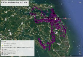
October 13, 2011Our last satellite map showed Camellia on West Neck Creek at 1:00am Oct 10 (Yellow Arrow). He has not travelled far. He made one flight north to the Oceana Naval Air Station Golf Course on Oct 12 then right back to West Neck Creek where he has spent the last three nights between Holland Road and London Bridge Rd in Virginia Beach. As of this map at 7:00am Oct 13 (today – White arrow) Camellia appears to be in flight headed south over the Christopher Farms neighborhood off Holland Rd. Click map to enlarge.


