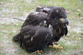
Camellia Still Touring Tidewater
Azalea Still at TRS Near Plymouth, NC
August 10, 2011Camellia Settles In Indian River, Chesapeake
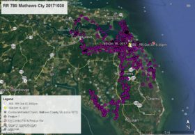
August 13, 2011Camellia continues to tour southside Tidewater. Trying to follow his track was a challenge this time. Camellia was on West Neck Creek at 6:00am Aug 7. From there he flew north about 11:00am to the mouth of the Lynnhaven River on Shore Dr near the Lesner Bridge. He did a u-turn there and flew to Stumpy Lake Golf Course in Va Beach and stayed overnight. On Aug 8 about 11:00am he flew to Trashmore II (Va Beach landfill) then southwest to the Southern Branch of the Elizabeth River (Azalea was here about 10 days ago) and stayed overnight. He left here flying over Portsmouth then to the Eastern Branch of the Elizabeth River before turning south and returning to Trashmore II where he was at 1:00am this morning Aug 10 – white arrow.


2 Comments
This is so awesome to be able to keep up with his travels. Thank-you Reese. Life is good.
Can we tell from this site how many miles between flight stops? Sure would be interesting! thanks –
Alice
Response – While the maps provide a lot of information and I can add the names of roads, counties, cities, rivers, etc, the one thing that is not available is a mileage scale. To add to the difficulty is that every map is at a different scale, so the mileage is different on every map. I’ll try to add some reference to distance in my comments on future posts.