Camellia Remains on Elizabeth River
Azalea Back In Washington County, NC
June 21, 2011Azalea Remains at Tidewater Research Station
June 24, 2011
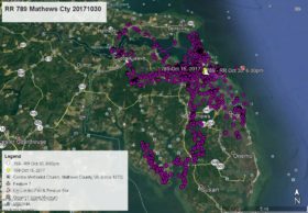
As he has done many times, Camellia is exploring an area in depth, staying for an extended time. This time it is a place where he has spent a great deal of time in the past, so must know quite well – the Eastern Branch of the Elizabeth River around Military Highway (Route 13) at the Norfolk/Virginia Beach border. At 1:00 am June 20, 21, and 22 he was at the end of Ballyinn Rd (used to be known as Ballyinn Farm) on the west side of Militery Hwy on King Creek. June 21 he flew back and forth across the Elizabeth River between Virginia Beach and Norfolk. On June 22 about 10:00am he flew east across Militery Hwy to the River Forest Shores neighborhood and stayed the rest of the day. As of this map at 1:00am June 23 he appears to be spending the night perched on top of a boathouse off W. McGinnis Circle – white data point. Click on map to enlarge.


