Camellia Still At Charity Neck May 30
AZ and CAM at Red Wing GC Together
May 28, 2011Azalea On Way Back To Catfish Farm??
May 31, 2011
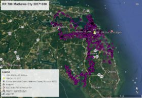
During the daytime on May 28, 29 and 30, Camellia has wandered a couple miles south from Charity Neck to near the intersection of Muddy Creek Rd and Shipp’s Cabin Rd. But the rest of the time he has remained at the farm field where the cell tower is being constructed. Camellia spent the nights of May 26, 27, 28, 29, and 30 on the edge of the woods in the upper right corner of the map. As of this map at 7:00am May 30 he was at Shipp’s Cabin Rd – white data point. Click map to enlarge


1 Comment
Is there somewhere I can count the number of miles they fly in a particular tracking day?
Thanks,
PS I am new to the tracking so be patient. They seem to both pass the stage where we worry about failure to thrive!
Response – We do not have that data, but the distance traveled varies widely from just a couple miles to well over 100 miles in a day like Azalea did on May 30.