Azalea on Nanney's Creek in Va Beach
Camellia Returns to Back Bay in Va Beach
May 1, 2011Azalea on Nanney’s Creek in Va Beach
May 1, 2011
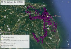
Azalea remains in southern Virginia Beach flying about between the North Landing River at Munden’s Point to Back Bay and Nanney’s Creek (also called Nawney Creek). She flew around the farm lands and returned to Munden Point to spend the night of April 28. She then flew to the area of Nanney’s Creek Rd and Mill Landing Rd and spent the nights of April 29 and 30. As of this satellite map at 10:00am April 30 she is near the mouth of Nanney’s Creek where it enters Back Bay – white data point. Azalea and Camellia are in the same area. I will put a joint AZ/CAM map together later today.


4 Comments
Reese, THANKS for all you do! Maybe the kids will do a flyover near your home again and visit their “step-Dad”. The right decision was made for the babies…You and ALL of the others are Amazing!
I am in awe of what science can accomplish. ‘Back in the day’ we perched for hours with binocs and a notepad — now we are armchair observers, I am truly appreciative, but miss the stinging early morning wind.
thanks for this.
k
Thank you Reese for these wonderful updates on Azalea and Camelia. Makes us feel closer to them and great that they are so close to the locals and NBG. Look forward to your map later. Thanks again. Carolyn
It’s so great to hear that Azalea and Camellia are in such close proximity to each other. Will check back for your AZ/CAM map.
I know that my opinion that bald eagles should be discouraged from nesting near the airport is not popular, but the risk to them is just too high. I wish that another nest could be found where the public could have access to view them and a web cam could be installed.
Thanks so much for all of your hard work to keep us informed about the eagles!