Azalea Re-Exploring Little Wicomico River
Camellia Remains in King George County Oct 13
October 13, 2010A landfill weekend
October 18, 2010
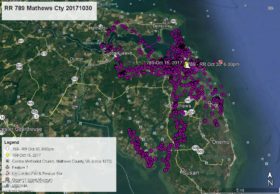
Azalea has spent the past couple weeks re-exploring parts of Northumberland County, VA with which she became familiar last fall. She has been concentrating on the Little Wicomico River, Reedville, Smith’s Point and the area at the mouth of the Potomac River on Chesapeake Bay. As of this satellite map at 8:00am Oct 13 she is at Vir-Mar Beach on the Potomac River.
The second map shows the relative location of Camellia (red) and Azalea (green).


2 Comments
Azalea’s map with position points and lines of green (and magnification) are very easily read (awesome)! The lower map with Camellia’s points and lines is readable too, the county boundaries help alot.
I was scouting out the Fairview Beach area this week (Monday evening!!), and went up to VirMar Beach Road about 3 weeks ago. (Have pics of both areas — but no juvies sighted!)
Reese, thanks so much again. I will try to go eagle tracking Sunday (17th)! Probably just Cammie who’s a bit closer.
Yes, thanks Reese for these maps. The “relative location” map was a great idea! I’d like also to thank you here, since I found no more room on the 10/06 blog, for once again educating me…first, about bald eagles, and now, hawks. More exciting than the hawk, I must admit, is the BALD EAGLE nest we have also discovered, just a few blocks from our home!! We spent 45 min. one day in our boat following one of the eagles as it flew across the lake and came to rest in a tree just off shore (not its nest tree). We couldn’t believe our great fortune!